Hi Kate, in classic I have some settings to avoid unaccuraty coordinates by telling the CyberTracker save if “Sighting accuracy” is reached. The Saving process waits a little bit to reach this accuracy. I see in my smartphone, if I use GPS not permanently and have only access in moment of save, that the coordinates are a little wrong. But - honestly - the effect is hard to understand, because the accuracy of GPS by itself can be wrong because of conditions. But: I’m at 2100m hight and there is nothing than open sky. So I cannot understand why some points have failure of around 10 m.
Some ideas? May be tommorow I will make same test with classic and online app at the same time and on same location.
And … the dots are to big. Is there a possibility to make it smaller?
Thanks for help
Holger
Hi Holger
When you say there is a failure of about 10m, are you talking about the captured GPS co-ordinate itself (what you would see in the table/CSV, the lat/longitude), or are you talking about the placement on the map?
Say you stand in the same position and capture a sighting in both CyberTracker Classic and Online, are you saying that the recorded latitude and longitude in the two would be different?
Kind regards, Kate
If you use a track timer, then the GPS will be kept on - this can improve quality of readings.
The main settings page has an option for GPS accuracy in meters. You can dial that down and see if it helps.
Cheers,
-Justin
Unfortunetaly because of internet probleme here, my last post was goimg to Nirvana. Justin, track timer was set to 30seconds in all the cases. The accuracy is defently more worst as im Germany. Covering of satelites? But im in a hight of 2100m. May be wheather? we are in cloudes. Maps? Definitely bad for Nepal.
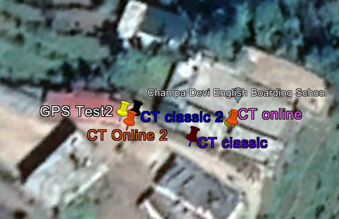
I’ll try again: 2nd Test: I’ve used 3 Tools and make coordinates at one place, than moved to 2nd place and do it again.:
- (1) App “GPS Test” (shows me accuracy of 4 m)
- (2) CT Online
- (3) CT classic.
Point1:
(1) 27.37455694, 86.40558000
(2) 27.37460, 86.40570
(3) 27.374593708786, 86.4056927565475
Point2:
(1) 27.37462389, 86.40538056
(2) 27.37460, 86.40540
(3) 27.3746245868217, 86.4054158860854
If you put it f.i. in Google Earth, you’ll find out that all coordinates are more or less unaccurate. But all of them points around 10m to north left. So I think, there’s a map problem?
In my my example, the rounding in the 5th position after decimalpoint gives an error of 3m. This is much to high! Because its an addition to the GPS-unaccuracy by itself.
Hi Holger
Nice testing, thanks.
Here is what we receive from the mobile for your points 1 and 2 in Online:
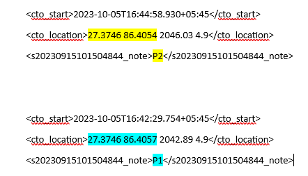
So the mobile only sends us co-ordinates to 4 decimals.
As a matter of interest, the other two numbers in the cto_location field are altitude (eg. 2042.89m) and accuracy (eg 4.9m).
Kind regards, Kate
Thanks Kate, interesting! It means some things in my eyes:
- Coordinate accuracy is nearly the same in all 3 Apps, CT online 4.9 and Ct classic 4.9, GPS-Test 4 (don’t have decimals).
- CT online App sends not so much decimals (I think, this is one part of the problem) → @Justin, would it be possible to round 2 decimals later? @Kate: Why stands the “0” at the end of the coordinates?
- The maps are not good and/ or GPS-Signals are unaccurate here.
=> 3 + 4 makes me thinking I can not use for my purpose (here)
Hi Holger
We allow for 5 decimals, so if we only get 4 then we fill it up with a 0 on the end.
If Justin changes to send 6 decimals from the mobile then we probably need to make a change as well to handle/display/map that.
Kind regards, Kate