Hi cybertracker support,
I have built a new project using the GPS snap tools. So, I get the latitude and longitude but I can’t see the point of my requests on map 1. What should I do?
I’m wondering how to extract the photos with all the columns in my active query table ?
Best regards,
Hello Jerom,
I’m not really sure what your problem is exactly. My supposition is, that you are new at CyberTracker? Please correct me if I’m wrong.
Do you see your collected data in “Inspector”-window? Can you send a snapshot of Reportr->Query? May be it will help.
By the way: Do you know the help videos from Justin here → Videos | CyberTracker Wiki? May be some is helpfully for you.
Cheers
Holger
Hello,
Thanks for your answer, I have already seen all the help videos. Please, how can I record the GPS coordinates from the screen without using the GPS snap tool ?
cheers,
Jerome
If you activate “Take GPS reading” in Layout dialog of Save screen/ save button than GPS coordinates are stored.
Cheers, Holger
Hi Jerome,
If you uncheck “Take GPS reading” on the Navigator and use a “Snap GPS Position” Action on the screen you want to take a GPS reading on, then the Save operation will be instant (no black triangle).
To be sure that the GPS is ready, enable the track timer and set it to less than 60 seconds. The easiest way to do this is Edit Application->GPS Tab->Track timer (seconds) = 59.
Cheers,
-Justin
Hi,
Is it possible to change the snap GPS coordinate display from decimal degrees to UTM, please ?
Cheers,
Jerom
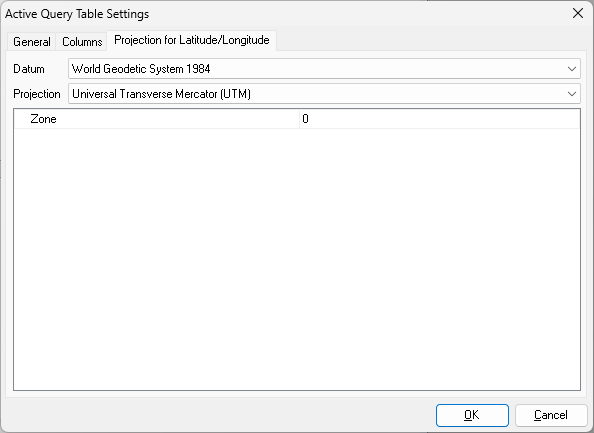
Hi Jerom,
If you mean on the desktop, then yes. With the table view active, click “Edit View” on the toolbar and go to the “Projection” tab:
Cheers,
-Justin